Environmental Studies and Forestry
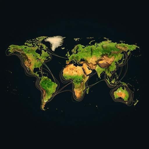
Protected-area targets could be undermined by climate change-driven shifts in ecoregions and biomes
S. Z. Dobrowski, C. E. Littlefield, et al.
This groundbreaking study investigates the critical impact of climate change on the global protected area network and biodiversity patterns. Conducted by an expert team including Solomon Z. Dobrowski and Caitlin E. Littlefield, it reveals that approximately half of the terrestrial landscape will face climate conditions that alter ecosystem representation, challenging conservation efforts.
~3 min • Beginner • English
Introduction
The study investigates how climate change may alter the spatial representation of biodiversity within the global protected area (PA) network, particularly when conservation targets are set using ecosystem-level units such as ecoregions and biomes. Static, place-based conservation schemes risk becoming misaligned with future biodiversity patterns as species assemblages and ecosystems shift under warming. The authors posit that climate-driven changes will challenge the efficacy of achieving area-based targets (e.g., 30% protection per ecoregion) and call for approaches that explicitly incorporate projected climatic shifts. They frame the research around quantifying potential transitions of ecoregions and biomes under +2 °C warming, evaluating consequences for meeting protection targets, and identifying stable and intact areas that could anchor PA expansion.
Literature Review
Methodology
The authors applied a reverse spatial climate analog approach to project potential shifts in terrestrial ecoregions and biomes under a +2 °C global mean warming scenario. Climate characterization used four variables from TerraClimate (~4 km): mean minimum temperature (Tmin), warmest monthly mean maximum temperature (Tmax), annual actual evapotranspiration (AET), and climatic water deficit (CWD), summarized for the 1961–1990 reference period. Future conditions at +2 °C relative to pre-industrial were derived via pattern scaling using outputs from 23 CMIP5 GCMs (RCP8.5 for 2070–2099 vs 1850–1879), producing model-median changes in means and interannual variability; a factor of 1.65 adjusted for the 0.35 °C baseline offset between 1961–1990 and pre-industrial.
For each terrestrial ~4-km pixel (focal cell), candidate analogs were searched within a 2000 km radius to largely constrain matches within continents and exceed typical biotic dispersal over mid-century horizons. Climatic dissimilarity between focal future climate and candidate reference climates was quantified using Mahalanobis distance scaled by local interannual climate variability, standardized to sigma dissimilarity (σα) via the Chi distribution. For each focal cell, the 100 lowest-σα reverse analogs (σα ≤ 2) were retained; σα > 2 indicated regionally novel climates (no-analog conditions).
Ecoregions (847 total, organized into 14 biomes, from Dinerstein et al. based on Olson et al.) were used as planning units; hydrologically defined biomes (e.g., mangroves, flooded grasslands) were excluded from ecoregion- and biome-level analyses, yielding 759 ecoregions in the reference period and 703 under +2 °C due to disappearances. PA data came from WDPA, including IUCN categories I–VI, excluding marine and proposed areas. Additional non-categorized PAs were included if their mean Human Modification Gradient (HMG) was ≤ the 80th percentile of HMG across IUCN I–VI PAs, increasing PA coverage by ~30%. Polygons were rasterized to TerraClimate resolution, retaining cells >75% protected. Intact areas were defined as HMG < 0.1.
Projected ecoregion for each focal cell was assigned by plurality vote of the ecoregions associated with its 100 analogs. Cells retaining their current ecoregion were deemed stable; others were considered transitions. Percent protected (PP) was computed for each ecoregion for reference and future assignments, holding PA area constant; ΔPP (APP) measured change. Bootstrapping (10,000 resamples of ecoregions within a biome) produced 10th–90th percentile uncertainty for biome-level APP means. Uncertainty was further characterized by spatial patterns in σα and strength of plurality votes. Areas with insufficient climate data, inland water, permanent ice/rock with no AET, or very low ICV (precluding σα calculation) were excluded from assignments.
Key Findings
- By mid-century under +2 °C warming: 53.9% of global land area is projected to experience climates corresponding to different ecoregions; 21.8% to different biomes.
- Within protected areas (PAs): 58.2% of PA land is projected to transition between ecoregions (p = 0.01); 20.6% between biomes (p = 0.58 vs non-PAs).
- Regionally novel climates (no suitable analogs within 2000 km): 3.6% of total land and 4.6% of PA land, concentrated in the Amazon, southeastern U.S., tropical/subtropical Africa, Arabian Peninsula, India, and northern Australia.
- Latitudinal peaks in transition potential occur in northern mid-latitudes (~30°–60° N) and southern tropical to subtropical latitudes (~0°–30° S), which also tend to have lower PA coverage.
- Biome representation: Tropical Broadleaf Forests, Temperate Conifer Forests, and Tundra are over-represented in PAs; Temperate Grasslands and Temperate Broadleaf Forests are under-represented. Net declines (percentage basis) are largest in Tropical Conifer Forests, Tundra, and Montane Grassland & Shrubland; Tropical Dry Broadleaf Forests show the largest net increase.
- Protection status: Mean PP across ecoregions remains similar (current 15.4% vs +2 °C 16.1%), masking substantial shifts. Significant biome-level increases in APP are expected for Tropical Dry Broadleaf Forests, Temperate Grasslands & Shrublands, and Mediterranean Forests & Scrub; declines for Tundra and Montane Grassland & Shrubland (with wide CIs).
- Ecoregion targets: Currently, 16.8% of ecoregions (n = 128) meet or exceed 30% protection. Under +2 °C, these 128 lose on average 16% of their protected area, and roughly one-quarter fall below the 30% threshold. About 8.6% of ecoregions have APP gains or losses exceeding 20%.
- Disappearing ecoregions: 56 ecoregions (~6%) have no reverse analogs under +2 °C; 24 of these are in Tropical & Subtropical Moist Broadleaf Forests.
- Stability and opportunity: 40.6% of current ecoregion area remains stable (same ecoregion). However, 55.9% of ecoregions have 30% protection targets exceeding their projected stable area; considering only unprotected, intact (HMG < 0.1), and stable areas, this rises to 86.8% of ecoregions. Of the area projected to remain climatically stable, 46% is currently intact. Stable, intact opportunities concentrate in high latitudes (Boreal, Tundra), mountainous Temperate Conifer Forests, and deserts, with limited opportunities in many tropical biomes, Temperate Grasslands, and Temperate Broadleaf Forests.
Discussion
Findings indicate that climate change will substantially reconfigure the distribution of ecoregions and biomes, undermining static, area-based representation metrics that underpin current and proposed protected area targets. Because more than half of land is projected to shift ecoregion classes and nearly a quarter to shift biomes, the proportion of each ecoregion protected will change even if total PA area remains fixed, leading to both gains and losses in representation and, in some cases, disappearance of ecoregions. Consequently, many ecoregions that currently meet a 30% protection target could fall below it under +2 °C.
The study provides climate-informed expectations to guide post-2020 Global Biodiversity Framework indicators and accounting, highlighting where representation metrics may be volatile. Strategically, conservation must incorporate climate-driven dynamics by: prioritizing stable and intact areas as refugia; planning for transitions via climatic connectivity (corridors along latitudinal/elevational gradients); considering investments in matrix and human-modified landscapes where intact-stable opportunities are insufficient; and targeting regions with remnant intactness and moderate transition potential (e.g., eastern South America, central/southern Africa, central Asia, northern Mexico, southern Australia). Analog-based projections can be applied from global to regional scales to identify anchor refugia, stepping stones, and sources of colonists, and to design climate corridors.
Conclusion
Climate change is likely to alter ecosystem representation within the global protected area network by mid-century, with widespread ecoregion and biome transitions, emergence of novel climates, and potential disappearance of some ecoregions. Static area-based targets tied to current ecoregion boundaries risk underrepresenting future biodiversity patterns. The authors recommend PA expansion and management strategies that explicitly account for climate-driven shifts: protect stable, intact refugia where available; enhance climatic connectivity across transitional zones; and incorporate matrix habitats to support species movements. Analog-based, scalable, and interpretable methods can support dynamic spatial prioritization and monitoring. Future research should refine analog approaches, compare their forecasting performance with other methods, and integrate species-level dynamics and disturbance regimes into conservation planning under climate change.
Limitations
- Ecoregions are used as coarse surrogates for ecosystem-level biodiversity; species responses may diverge within an ecoregion, and boundaries may not perfectly capture biotic patterns.
- Assumes a functional linkage between selected climate variables (Tmin, Tmax, AET, CWD) and ecosystem distributions; non-climatic drivers (e.g., soils, disturbance, biogeographic history) can modulate outcomes.
- Implicit equilibrium assumption between climate and biodiversity; real-world lags, dispersal constraints, and disturbance-driven threshold changes may cause disequilibrium.
- Climate analog approach uncertainties: potential underestimation of interannual climate variability using gridded data; confidence varies spatially (lower in tropics with low ICV; plurality strength varies). σα > 2 areas indicate no-analog conditions where projections are undefined.
- Climate projection uncertainties: reliance on pattern scaling and multi-model medians across 23 CMIP5 models; inter-model variability remains, and the approach does not explicitly quantify model structural uncertainty.
- Search radius limited to 2000 km to constrain analogs, which may miss more distant suitable analogs or cross-continental matches for highly mobile taxa.
- PA dataset augmentation via HMG thresholding may include some areas with heterogeneous management effectiveness; PA effectiveness is not assessed.
Related Publications
Explore these studies to deepen your understanding of the subject.

