
Earth Sciences
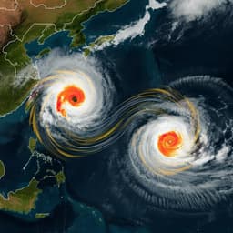
Increasing sequential tropical cyclone hazards along the US East and Gulf coasts
D. Xi, N. Lin, et al.
This groundbreaking research by Dazhi Xi, Ning Lin, and Avantika Gori uncovers alarming trends in sequential tropical cyclone hazards along the US East and Gulf coasts. With projections indicating a significant rise in the frequency of compound extreme events by 2100, this study highlights the urgent implications of climate change on storm impacts and returns periods.
~3 min • Beginner • English
Introduction
Compound extreme weather events can produce higher impacts than single hazards and are categorized as multivariate, spatially compounding, and temporally compounding events. Tropical cyclones (TCs) generate multiple hazards—strong winds, heavy rainfall, and storm surge—that can occur jointly and weaken coastal infrastructure, and temporally compounded sequences of TCs can amplify impacts because prior events reduce community and infrastructure resilience. Recent U.S. experiences (e.g., Hurricanes Ida and Nicholas in 2021) underscore sequential impacts. Prior studies have primarily examined joint (simultaneous) TC hazards, with limited work on triple hazards and no robust assessment of sequential TC hazards. It remains unclear whether sequential TC hazard occurrence shows historical trends, how to project such events given uncertainties in future TC frequency, and what physical mechanisms drive changes in sequential TC hazards. This study addresses these gaps by analyzing historical observations and climate simulations to quantify and project changes in sequential TC hazards at specific U.S. coastal locations and regionally.
Literature Review
The paper situates sequential TC hazards within the broader framework of compound events, distinguishing multivariate, spatial, and temporal compounding. Previous research has emphasized joint TC hazards (e.g., rainfall-surge compound flooding) and projected increases in TC intensity and hazard potential, along with indications that sequential landfalls may be becoming more likely. However, comprehensive analyses of triple hazards (wind, surge, rainfall) and temporally sequential TC hazards are lacking. Studies have also debated the relative importance of sea-level rise (SLR) versus storm climatology changes for extreme surge; prior work focused on very extreme events (e.g., 100-year surges), whereas this study considers moderate but impactful thresholds, highlighting differing sensitivities to SLR. Reported increases in TC rain rates and slowed translation speeds further motivate assessing sequential hazards.
Methodology
Historical analysis (1949–2018): The authors used U.S. landfalling TC records from IBTrACS (6-hourly positions and intensities) and hazard observations (hourly water levels, daily rainfall, daily maximum wind) at nine coastal sites spanning the U.S. East and Gulf coasts. Where tide gauges lacked wind/rain data, the nearest weather station within 100 km supplemented observations. Hazard-producing storms were defined using site-specific 95th percentiles of daily maximum water level, daily total rainfall, and daily maximum wind when a TC was within 250 km. A storm is hazard-producing if any hazard component exceeds its threshold on any day. Hazard duration comprises days with at least one hazard above threshold. The yearly minimal impact interval (MII) is the minimum interval between the end of one storm’s hazard and the beginning of the next storm’s hazard within a year (overlap yields MII = 0).
Probabilistic modeling and Monte Carlo: An extended Poisson–Gaussian model represented arrivals of hazard-producing storms as a non-stationary Poisson process with annual frequency A_hazard(t) and seasonal timing S_hazard(s) modeled by a Gaussian with mean μ and spread σ. Hazard durations D_i(t) were modeled non-parametrically via kernel density estimation for each site and climate state. For each year (ten-year moving averages for fitting), Monte Carlo sampling generated sequences of hazard-producing storms to estimate annual probabilities of sequential events (e.g., MII ≤ 10, 15, 30 days) and trends.
Future projections (2070–2100): Sequential hazards were projected under SSP5-8.5 and SSP2-4.5 using synthetic TCs generated by a statistical–deterministic downscaling model (Emanuel approach) driven by six CMIP6 models (CanESM5, CNRM-CM6-1, UKESM1-0-LL, EC-Earth3, IPSL-CM6A-LR, MIROC6). Large synthetic catalogs of U.S. landfalling storms were produced for each scenario and model (thousands of storms; multi-millennial equivalent years). Hazards were simulated as follows: storm tides (surge + tide) with ADCIRC on a North Atlantic unstructured mesh using parametric wind/pressure inputs; TC rainfall using the physics-based TCR model driven by C15 wind structure and environmental fields; 10-minute sustained wind using the complete wind profile model (C15) with environmental wind correction. Localized probabilistic SLR projections (IPCC AR6, localized tide-gauge-based) were sampled and combined with storm tides to account for SLR, assuming Poisson storm arrivals.
Joint/marginal hazard analysis: For regional coastal segments (TX, LA, MS-AL, West FL, East FL, GA, SC, NC), marginal exceedances of surge, rainfall, and wind were modeled with generalized Pareto distributions (thresholds selected via quantile MSE minimization). Dependence among hazards was represented with nested Gumbel copulas to capture tail dependence. Joint exceedance probability (JEP) and at-least-one exceedance probability (OEP) were computed for return-level thresholds (e.g., 7-year marginal return levels) to assess changes in single and joint hazards. Return periods T_JE and T_OE were obtained by dividing JEP and OEP by storm arrival rates. The sequential-event probabilistic model was then fitted to simulated hazards to infer return periods of MII levels with and without SLR, and with sensitivity tests holding storm frequency at control values to isolate hazard severity effects.
Threshold sensitivity: Main analyses used 95th-percentile thresholds; sensitivity tests used 90th and 99th percentiles (Supplementary).
Key Findings
Historical (1949–2018):
- At 7 of 9 sites (all but Charleston, SC, and Pensacola, FL), hazard frequency and duration increased since 1949, attributed to greater hazard-producing capability (likely increased intensity) and slower translation speeds. Probabilistic estimates show increasing annual probabilities of sequential TC hazards (e.g., MII ≤ 30 days) with some sites (e.g., Sandy Hook, NJ) roughly doubling over seven decades; absolute probabilities remained below ~10% for MII < 30 days.
Future projections (2070–2100):
- Strong shortening of MII return periods across the U.S. Gulf and East coasts. Example: In Texas, MII < 15 days shifts from a 40-year event (control) to 4-year (SSP5-8.5, no SLR) or 6-year (SSP2-4.5, no SLR), and to 2-year (SSP5-8.5, with SLR) or 3-year (SSP2-4.5, with SLR). Region-wide, MII < 15 days return periods decline from 10–92 years to 2–5 (2–11) years without SLR and to ~1–2 (1–3) years with SLR under SSP5-8.5 (SSP2-4.5).
- Decreases in MII return periods defined by hazards are larger than those defined by landfalls alone. Under SSP5-8.5 (SSP2-4.5), MII (15-day) return period decreases by 88.7–98.1% (86.6–97.1%) with SLR and 84.7–94.4% (81.7–90.2%) without SLR, versus 50.6–78.7% (48.6–74.0%) when defined by landfall, indicating contributions from both increased landfall frequency and increased hazard severity.
- Sensitivity holding storm frequency at control values still shows substantial MII shortening, isolating the effect of increased hazard severity and SLR. Example: Texas MII < 15 days changes from 40-year to 22-year (28-year) without SLR and 9-year (11-year) with SLR under SSP5-8.5 (SSP2-4.5). Regionally, MII < 15 days decreases from 10–92 years to 8–46 (7–70) years without SLR and to 3–10 (4–12) years with SLR, showing severity and SLR alone can produce large increases in sequential hazards.
Mechanisms and hazard composition:
- Increased hazard severity (particularly rainfall and surge) and longer hazard durations amplify sequential risks. The share of landfalling storms producing at least one hazard increases markedly: from 25.4–43.7% to 35.9–54.0% (80.1–85.3% with SLR) under SSP5-8.5 and to 27.9–53.6% (75.8–82.9% with SLR) under SSP2-4.5. Joint-hazard return periods decrease substantially across regions.
- Without SLR, rainfall becomes the leading single hazard in many regions by mid-late century, with rainfall-hazard-producing ratios increasing 67.5–125.4% (45.9–59.2%) under SSP5-8.5 (SSP2-4.5). Example (Louisiana): hazard-to-landfall ratios shift from surge 35.0%, rain 29.2%, wind 24.2% (control) to surge 41.7% (40.5%), rain 48.9% (43.2%), wind 36.8% (34.8%) under SSP5-8.5 (SSP2-4.5).
- With SLR, surge becomes the dominant driver of hazard production: surge-producing ratios reach 79.3–84.7% (74.5–82.5%) under SSP5-8.5 (SSP2-4.5). Relative increases in surge-producing TCs are 126.1–379.1% (113.6–352.9%), and overall hazard-producing ratios rise 93.6–223.0% (83.9–215.9%). SLR especially transforms previously weak/distant TCs into surge-hazard-producing and lengthens hazard durations significantly (mean duration increases are statistically significant at many regions, Fig. 4), further elevating sequential risk.
- Differences between SSP5-8.5 and SSP2-4.5 are modest for general sequential hazards (e.g., 89–98% vs 87–97% decreases in MII < 15 days return periods), but SSP5-8.5 shows more sequential extremes.
Grey swan sequential extremes:
- No instances of a “Katrina-like” (>8 m water level at any coastal site) and a “Harvey-like” (>1000 mm rainfall at any coastal site) storm within 15 days occur in a 1,375-year control simulation. In the future, return periods for such sequential pairs are ~250 years (SSP5-8.5) and ~1,300 years (SSP2-4.5) without SLR; with SLR they shorten to ~85 years (SSP5-8.5) and ~650 years (SSP2-4.5). Under SSP5-8.5 by late century, annual probabilities exceed 1% for such sequential extremes, indicating emerging risks to national-scale emergency response capacity.
Discussion
The study demonstrates that sequential TC hazards—defined by short minimal impact intervals between hazard-producing storms—have increased historically at many U.S. coastal sites and are projected to rise sharply under climate change. The analysis connects these trends to two primary mechanisms: (1) increases in landfall frequency in some projections, and more robustly, (2) substantial increases in hazard-producing capability (rainfall, surge, wind), with SLR critically elevating coastal water levels and expanding the set of storms that become hazardous. Longer hazard durations also heighten the likelihood that hazards from successive storms overlap or arrive within short windows, compounding impacts. By explicitly modeling triple hazards and their dependence and embedding them in a probabilistic sequential framework, the study clarifies how changing storm climatology and SLR jointly reduce MII return periods. The findings highlight that even under a moderate emissions pathway (SSP2-4.5), sequential hazard risks intensify comparably to the high pathway for general events, though extreme sequential events are more frequent under SSP5-8.5. These results are relevant for coastal risk management, emphasizing the need to plan for clustered storms, resource allocation challenges, and adaptation to SLR to mitigate compounding risks.
Conclusion
The paper provides the first comprehensive quantification of historical and projected changes in sequential TC hazards along the U.S. East and Gulf coasts, integrating observations, physical hazard modeling, and probabilistic event sequencing. Key contributions include: defining and applying MII as a sequential-hazard metric across triple TC hazards; demonstrating historical increases in sequential hazard probabilities; projecting strong decreases in MII return periods driven by increased hazard severity and SLR; and revealing elevated probabilities of unprecedented sequential “grey swan” extremes under high emissions.
The authors suggest that, although general sequential hazard increases are similar under SSP2-4.5 and SSP5-8.5, high-emission futures entail greater risks of extreme sequential events. Adaptation to SLR can substantially influence future sequential hazard probabilities by reducing surge-driven hazard days. Future research should refine SLR projections and their local expressions, improve understanding of how SLR converts weak TCs into surge-hazard-producing events, further constrain future TC frequency and structure changes, and evaluate infrastructure and emergency management strategies under sequential and compound extremes.
Limitations
- Observational limitations: Scarcity of observed sequential hazard events and missing wind data (especially 1949–1979) complicate trend detection; the study mitigated this by probabilistic modeling and by analyzing surge/rain-only subsets.
- Model assumptions: Synthetic TC catalogs assume conditional independence and rely on downscaling parameterizations (e.g., storm size assumptions, C15 wind structure); regional hazard dependence modeled via Gumbel copulas and GPD marginals introduces parametric uncertainty.
- Threshold choices: The 95th-percentile definition of hazard-producing is ad hoc (sensitivity tested at 90th/99th percentiles) and may not reflect all infrastructure vulnerabilities.
- SLR and frequency uncertainties: Localized SLR projections (AR6) and future TC landfall frequency have substantial uncertainties; projections are provided with and without SLR and with sensitivity holding frequency constant.
- Spatial scope: Historical analysis covers nine coastal sites; while projections span regional segments, site-specific results may not generalize to all locations.
- Tide-surge terminology: “Surge hazard” refers to storm tide plus SLR; extreme surge components vs moderate thresholds may respond differently to SLR than indicated in studies of centennial extremes.
Related Publications
Explore these studies to deepen your understanding of the subject.