
Environmental Studies and Forestry
The unprecedented 2023 Canadian wildfire season: extreme weather, landscape legacies and the societal impacts
P. Jain, Q. E. Barthelemy, et al.
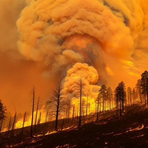
The 2023 Canadian wildfire season has reached unprecedented levels, burning around 15 million hectares and revealing the alarming impact of extreme weather events. This comprehensive study, conducted by Piyush Jain and a diverse team of experts, delves into the driving factors and highlights the severe consequences for both society and environment.
~3 min • Beginner • English
Introduction
This study examines the record-breaking 2023 Canadian wildfire season, investigating how extreme weather, early-season conditions, and persistent large-scale atmospheric patterns contributed to unprecedented burned area, fire size, and duration. The work explores the roles of rapid snowmelt, drought development, extreme fire weather, and atmospheric blocking in enabling extensive fire growth and a prolonged fire season, and documents associated societal and ecosystem impacts. The purpose is to characterize drivers, quantify fire activity and impacts, and provide context for future fire management under a warming climate.
Literature Review
Prior research has documented increasing fire weather severity and lengthening fire seasons in Canada and North America associated with warming temperatures and reduced atmospheric humidity, with implications for higher area burned and more frequent extreme fire weather. Studies highlight the influence of large-scale circulation patterns, including Rossby waves and atmospheric blocking, on extreme heat and fire activity. Work on fire impacts emphasizes health risks from wildfire smoke (PM2.5), evacuation dynamics, and vulnerabilities at the wildland–human interface. Ecologically, recent literature shows that repeated or frequent fires, drought, and other disturbances can challenge boreal forest resilience, alter regeneration dynamics, reduce carbon stocks, and shift landscapes toward more open ecosystems. This study builds on these findings by integrating multi-source datasets to analyze the 2023 season’s exceptional conditions and outcomes.
Methodology
- Fire perimeter dataset: Constructed a 2023 hybrid perimeter dataset (NBAC-M3) by combining preliminary National Burned Area Composite (NBAC) perimeters with Natural Resources Canada M3 buffered hotspot perimeters for unmapped areas (~18% of 2023 burned area). Water bodies were removed using CanVec hydrographic polygons. To correct M3-buffered area overestimation (due to unburned islands and water), ecozone- and year-specific calibration factors were derived by dividing historical NBAC area burned by M3 buffered hotspot area for 2012–2022, then applied to 2023 M3 polygons within ecozones. Polygons <1 ha were removed. Calibrated M3 areas were summed with NBAC-mapped areas to estimate total 2023 burned area.
- Land cover burned: Intersected NBAC-M3 perimeters with SCANFI classified land cover raster (Water, Rock, Bryoid, Herbs, Shrub, Treed broadleaf, Treed mixed, Treed conifer), excluding nonfuel, to compute proportions burned by province/territory (Table S2 referenced).
- Daily fire growth: For all NBAC-M3 fires ≥500 ha final size, day-of-burning was estimated by interpolating detection dates from satellite hotspots (corrected to local standard time) using ordinary kriging to a 180-m grid, following established methods. Detections prior to April 1 were filtered to remove false detections. In total, 641 fires were interpolated (~99.5% of total 2023 burned area).
- Snowmelt timing: Daily snow cover (IMS, 4-km resolution) provided snowmelt timing per pixel as the first day of the longest snow-free period each year. 2023 departures were computed as anomalies (days) relative to 2004–2022 mean timing.
- Drought: Root Zone Soil Moisture (RZSM; top 1 m) from GLDAS-2.2 (daily, 0.25°) was used to detect rapid-onset drought by identifying the maximum 14-day reduction in RZSM within a sliding window from May 1–June 30, and the timing (midpoint) of that maximum drying.
- Weather and fire weather: ERA5 reanalysis (0.25°, hourly) provided 2-m temperature, dewpoint, precipitation, and 10-m winds. Relative humidity and vapor pressure deficit (VPD) were derived from temperature and dewpoint (Alduchov & Eskridge). Mean daily anomalies (May 1–Oct 31, 2023) were computed against a 1991–2020 baseline; 2023 seasonal means were also ranked against 1940–2023. Canadian Fire Weather Index System (CFWIS) outputs were computed from ERA5 with overwinter Drought Code treatment and fire-season definitions based on temperature thresholds (startup: Tmax >12 °C for 3 consecutive days; shutdown: Tmax <5 °C for 3 consecutive days). Extreme fire weather thresholds (FWI95) were defined per grid cell as the 95th percentile of FWI during 1991–2020. Extreme fire weather days were those with FWI > FWI95. The spatial extent of extreme conditions was quantified over forested areas (MEASURES VCF canopy cover >20%).
- Atmospheric blocking: Persistent positive anomalies in 500-hPa geopotential height (≥1 SD above local seasonal climatology for 1991–2020), persisting ≥5 days and reaching ≥100,000 km2, were identified following a published algorithm over forested Canada. The sum of days with such anomalies per location served as a proxy for blocking days.
- Air quality: PM2.5 concentrations were drawn from the first 24-hour outputs of ECCC’s operational FireWork system (GEM-MACH at 10-km resolution) with near-real-time wildfire emissions from CFFEPS for VIIRS hotspot locations, driven by forecast meteorology and fuel data. Outputs provided hourly PM2.5; comparisons referenced Canadian Ambient Air Quality Standards (24-h average 27 µg m−3; annual 8.8 µg m−3). Air Quality Alert Bulletins (MSC-ECCC, 2017–2023) were compiled, noting each alert includes issuance and termination plus continued bulletins.
- Evacuations: Evacuation data (1980–2023) were obtained from the Canadian Wildland Fire Evacuation Database via media reports and quality control methods; 2023 figures are provisional.
- Data availability: Supporting datasets and external sources (IMS snow cover, GLDAS-2.2, ERA5, NASA FIRMS, etc.) are cited with DOIs/links in the data availability section.
Key Findings
- Unprecedented fire activity: Approximately 15 million hectares burned nationally in 2023, about seven times the national average and roughly 4% of Canada’s total forest area, shattering national and multiple regional records.
- Large fire occurrence and dominance: 834 large fires (≥200 ha) occurred, more than 2.5 times the 1986–2022 average of 320. The number and impact of very large fires (>50,000 ha) were exceptional: 60 such fires accounted for 73% of the total area burned (historical average: 7 fires accounting for 41%). Wildfire complexes (mergers of multiple fires) produced 6 of the 10 largest, long-burning wildfires on record.
- Fire duration and regional contrast: Of 43 very large fires in western Canada (west of 85°W), median duration was 82 days (90% CI: 32–156), whereas 17 very large fires in eastern Canada had a median duration of 40 days (90% CI: 22–89), underscoring the link between longer duration and larger final size.
- Extreme fire weather and blocking: The mean number of April–October atmospheric blocking days in 2023 reached about −50 across much of Canada, far exceeding the baseline (1991–2020) mean of about −15, aligning with persistent and widespread extreme fire weather that facilitated fire growth. Extreme fire weather days (FWI > local 95th percentile) were extensive and persistent across multiple provinces/territories during the core season.
- Early-season predisposition: Many regions experienced early snowmelt, rapid root zone soil moisture drying (flash-drought-like dynamics) in May–June, and elevated Drought Code anomalies, creating highly receptive fuels ahead of peak burning.
- Fire management and outcomes: Despite record suppression efforts (including substantial interprovincial and international resource sharing), only about 85% of full-response fires were held under 200 ha, compared to 62% of modified/monitored-response fires that remained below 200 ha, highlighting the overwhelming conditions.
- Societal and health impacts: Hundreds of thousands of people experienced evacuations and disruptions; eight wildfire personnel lost their lives. Smoke exposure affected millions across North America, with widespread air quality warnings and elevated PM2.5, implying significant public health burdens.
- Ecosystem impacts: About 87.5% of burned area was forest, with substantial burning of conifer and mixedwood forests and notable burning of broadleaf forests in Alberta. Over 1 million hectares of young forests (<30 years) burned, with 300–400 thousand hectares in Quebec’s commercial forests potentially facing regeneration failure. Anticipated outcomes include reduced forest productivity and carbon stocks and shifts toward open taiga, prairies, or parklands, with near-term biodiversity impacts favoring early-seral species while negatively affecting old-growth-dependent species.
Discussion
Findings indicate that an early and rapidly drying landscape, combined with persistent extreme fire weather and prolonged atmospheric blocking, created an environment highly conducive to sustained fire spread across Canada in 2023. The strong relationship between the number of extreme fire weather days and fire size, alongside extended fire durations—especially in western Canada—demonstrates how longer windows without fire-ending events (e.g., significant rain or winter onset) translate into very large fires. The prevalence of unprecedented blocking suggests a synoptic-scale driver of recurring heat and dryness, consistent with a warming climate that increases vapor pressure deficits and dries fuels. Management capacity was strained by nationally synchronous extreme conditions, despite significant resource mobilization. The societal consequences, including evacuations and smoke-related health risks, underscore the wide-ranging impacts beyond burned area. Ecologically, the concentration of burning in forests, the substantial impact on young stands, and the risk of regeneration failure pose long-term challenges for forest structure, carbon storage, and biodiversity. These results align with projections that anthropogenic climate change increases the likelihood of seasons like 2023, where a small number of extreme days can dominate seasonal burn totals, implying elevated future risk without substantial adaptation in fire management and landscape strategies.
Conclusion
The 2023 Canadian wildfire season was exceptional in extent, intensity, and duration, driven by early-season drying, persistent extreme fire weather, and frequent atmospheric blocking. Burned area (~15 Mha) far exceeded recent decades, with an unusual dominance of very large fires that were sustained by prolonged windows of spread-favorable weather and a scarcity of fire-ending events. Societal impacts were profound, and ecological consequences include elevated risks of regeneration failure and long-term shifts in forest composition and function. Anthropogenic climate change facilitated these conditions, consistent with expectations of increased heat and moisture deficits. Future directions include disentangling the relative influence of human landscape legacies versus worsening fire weather, improving integration of climate and fuel dynamics in risk assessment, expanding proactive and innovative fire management and mitigation strategies, and strengthening cross-jurisdictional coordination to manage nationally synchronous fire activity.
Limitations
- Data completeness and provisional status: 2023 evacuation data are provisional and may be updated. Approximately 18% of 2023 burned area relied on M3 buffered hotspots adjusted via ecozone-specific calibration factors; despite corrections, residual uncertainty in burned-area estimates remains.
- Methodological assumptions: Kriging-based day-of-burning interpolation and filtering of early detections may introduce spatial/temporal uncertainties in daily growth estimates. Using reanalysis (ERA5) to compute fire weather indices (FWI, VPD) introduces model and representativeness errors, particularly in complex terrain or sparsely observed regions.
- Indices and thresholds: Defining extreme fire weather via local 95th-percentile FWI accounts for spatial heterogeneity but depends on the chosen baseline (1991–2020) and fire-season definitions. Blocking identification relies on specific anomaly and persistence thresholds that may affect counts.
- Air quality modeling: PM2.5 fields are from an operational forecast system (FireWork/GEM-MACH) with uncertainties in emissions, chemistry, and meteorology; comparisons to standards are indicative, not observationally derived.
- Scope: Some regions (e.g., Nunavut) were excluded from selected analyses due to low forest cover and area burned, and not all ancillary factors (e.g., suppression tactics, fuel treatments, ignition sources) could be fully resolved at national scale.
Related Publications
Explore these studies to deepen your understanding of the subject.