
Earth Sciences
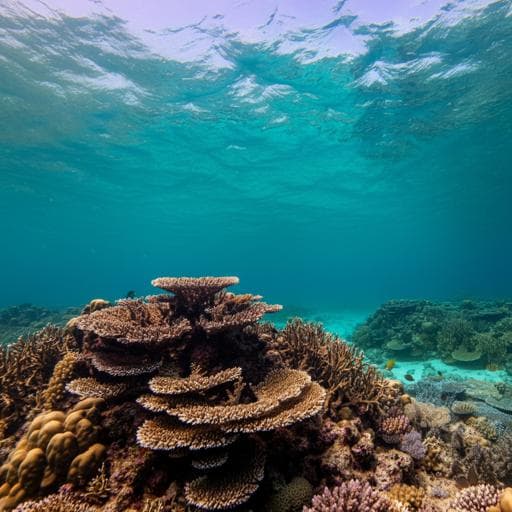
Sustained coral reef growth in the critical wave dissipation zone of a Maldivian atoll
P. S. Kench, E. P. Beetham, et al.
Discover groundbreaking research by Paul S. Kench and team that unveils a new method for measuring contemporary coral reef growth in the Maldives. This study reveals that coral reefs may keep pace with rising sea levels, a crucial insight for predicting future coastal hazard exposure.
~3 min • Beginner • English
Introduction
The study addresses whether Indo-Pacific coral reefs—particularly the shallow reef crest and outer reef flat that induce wave breaking—can accrete fast enough to maintain their wave-dissipation function under contemporary and future sea-level rise. The context is widespread concern that sea-level rise and degradation of reef calcifiers will reduce reef elevation relative to sea level, increasing wave energy transmission, flooding, and erosion on adjacent coasts. Prior estimates of contemporary reef growth rely largely on indirect carbonate budget approaches from deeper, forereef settings and involve assumptions when translating budgets to vertical accretion; they may underrepresent detrital contributions and do not directly measure the critical wave-breaking zone. This paper introduces a direct, repeatable method to quantify vertical accretion on the reef crest and outer reef flat of a Maldivian atoll, presents new contemporary growth data from these zones, and evaluates implications for maintaining wave protection relative to current and projected sea-level rise.
Literature Review
Holocene reef growth rates have ranged from ~1–20 mm yr^-1, reflecting variable sea-level histories and community composition. Contemporary growth estimates frequently derive from census-based carbonate budgets (G, kg m^-2 yr^-1) converted to linear accretion (mm yr^-1), yielding first-order vertical growth potentials of roughly −0.84 to 4.0 mm yr^-1, but with major regional variability and sensitivity to disturbance (e.g., bleaching). Limitations include uncertain G-to-accretion conversions, neglect of detrital infill and redeposition, and a focus on accessible forereef slopes (7–10 m depth) rather than the shallow crest/outer flat where wave breaking and dissipation occur. Reef crest zones differ ecologically (e.g., coralline algae dominance, wave-resistant morphotypes) and may respond differently to disturbances. Geological and experimental work indicates windward crest algal frameworks can achieve high accretion, but contemporary direct measurements of crest/outer flat accretion are scarce.
Methodology
Field site: Southern rim of Huvadhoo atoll, Maldives (0°32′N, 73°17′E), an oceanic atoll with a steep forereef (>2000 m to crest) and an intertidal reef flat. The study area is seaward of Keleihutta island, spanning the first ~65 m landward of the reef crest. Wave climate is monsoon-modulated with significant wave height typically ~1–2 m, and sea level rising locally at 3.46 ± 0.25 mm yr^-1 with interannual variability (ENSO/IOD). No extreme storms affected the site during the 2018–2020 measurement period.
Design: Four Coral Reef Accretion Monitoring (CRAM) sites established across eco-geomorphic zones: (1) reef crest dominated by crustose coralline algae (CCA) and encrusting corals; (2) and (3) outer reef flat coral–algal zone; (4) central reef flat algal pavement with low calcifier cover. A boulder tract between outer and central flat was not instrumented due to rugosity.
Instrumentation: Purpose-built Coral Reef Accretion Frames (CRAFs) define 0.25 m^2 plots (600×600 mm) using four bolts to establish a leveled horizontal reference plane. Two parallel level bars with grooves and a perpendicular measuring platform allow positioning of 99 slender rods at 5 mm spacing along each transect line. Seven transects per plot (693 point measurements per site) were recorded. For each point, rods were lowered to contact the reef surface; a graduated backboard was photographed with control points to capture rod protrusion heights.
Data processing: Images were rectified and digitized (Matlab grabit.m) to reconstruct reef surface topography relative to the fixed reference plane. Baseline February 2018 measurements were repeated in February 2019 and February 2020 to compute annual changes (mm yr^-1) at point, transect, and plot scales. Digitizing precision ~0.5 mm; overall CRAF repositioning/processing error ±1.07 mm determined from 10 repeat measurements on one transect.
Statistics: Inter-site differences in total elevation change (2018–2020) assessed using a one-way Kruskal–Wallis test; significant results followed by Dunn’s post hoc tests with Bonferroni adjustment. Accretion was also converted to net carbonate production (G, kg m^-2 yr^-1) using: G = (VAC/1000) × D, where VAC is net vertical accretion (mm m^2 yr^-1) and density D = 1576 kg m^-3 (mid-range from ReefBudget and Maldivian values). Measured accretion rates were compared with contemporary local sea-level rise (3.46 ± 0.25 mm yr^-1) and IPCC RCP 4.5 (6.9 mm yr^-1) and RCP 8.5 (9.6 mm yr^-1) scenarios by 2100.
Key Findings
- Direct, high-resolution measurements show dynamic millimetre- to sub-metre-scale topographic change across the crest and outer reef flat over 2018–2020, with significant differences among sites (Kruskal–Wallis H(3)=521, p=0.0001).
- Reef crest (Site 1, CCA/encrusting corals): Net accretion 13.2 mm over two years; mean annual 6.6 ± 12.6 mm yr^-1. Annual values: 5.4 ± 20.4 (2019), 7.8 ± 15.8 mm yr^-1 (2020). 93% of transects accreted. Point-scale changes ranged up to +134.8 mm and down to −92.0 mm in a single year.
- Outer reef flat Site 2 (coral–algal): Essentially stable; mean annual −0.07 ± 6.1 mm yr^-1, with transect means from −6.5 ± 10.4 to +6.0 ± 8.8 mm yr^-1; point-scale −66.5 to +49.9 mm.
- Outer reef flat Site 3 (coral–algal): Net accretion 6.1 ± 20.3 mm over two years; mean annual 3.1 ± 10.2 mm yr^-1 (3.2 ± 17.8 in 2019; 2.9 ± 13.4 in 2020). 78% of transects accreted; point-scale −96.0 to +104.3 mm.
- Central reef flat Site 4 (algal pavement, low calcifier cover): Mean annual −0.5 ± 1.8 mm yr^-1 (within ±1.07 mm instrument error; effectively no net change). Point-scale −13.1 to +16.8 mm.
- Organism-level growth inferred from co-located points: Nodular CCA up to 17–21.7 mm yr^-1 (mean 19.3); encrusting coralline algae ~4–6 mm yr^-1; encrusting corals up to ~11.0 mm yr^-1 (Pocillopora) and ~6.0 mm yr^-1 (Porites).
- Net carbonate production (G): Reef crest 8.51–12.51 (mean 10.39) kg m^-2 yr^-1; outer coral–algal zone across Sites 2–3: −1.11 to 4.98 (mean 2.35); algal pavement: −2.69 to 1.15 (mean −0.77).
- Relative to sea-level rise: Crest accretion (~6.6 mm yr^-1) exceeds current local SLR (3.46 ± 0.25 mm yr^-1), comparable to RCP4.5 (6.9) but below RCP8.5 (9.6), though variability spans higher rates. Outer flat with productive cover approximates current SLR but lags future scenarios; central flat shows no accretion capacity.
- Mechanisms of surface change include both constructive (calcifier growth, detrital infill, lateral overgrowth closing fissures) and destructive (physical breakage in wave zone, bioerosion by echinoderms and parrotfish) processes, with observed instantaneous structural losses up to ~57 mm and localized gains up to ~120 mm.
Discussion
Findings demonstrate that the reef crest—critical for wave breaking—currently exhibits positive accretion at rates capable of keeping pace with present local sea-level rise and near the moderate RCP4.5 scenario, while outer reef flat accretion is spatially variable and central reef flat shows negligible net change. The results underscore strong habitat-specific heterogeneity: CCA- and encrusting coral-dominated crest zones recover and accrete rapidly, even within two years of a major 2016 bleaching event, contrasting with reported post-bleaching carbonate budget collapses on deeper forereefs. This indicates that inferences about reef submergence and coastal hazard exposure based solely on forereef data may be misleading for wave-buffering performance. The observed suite of processes—calcifier growth, detrital infill, rubble deposition, and episodic physical losses—jointly governs net elevation change; functionally, absolute crest/flat elevation is what controls wave dissipation. While crest accretion may sustain wave protection under moderate SLR, slower accretion or slight lowering on landward flats suggests potential relative submergence and morphological transformations that could alter wave transmission and island flooding/erosion, necessitating updated wave modeling that incorporates zone-specific growth dynamics.
Conclusion
The study introduces and applies a direct, repeatable CRAF/CRAM method to quantify contemporary vertical accretion at millimetre resolution across the critical reef crest and outer reef flat. Measurements show sustained crest accretion (~6.6 mm yr^-1) capable of tracking current sea-level rise, with variable but positive accretion at parts of the outer flat and negligible change on central flat. These results provide ground-truthed evidence that crest zones can maintain wave-dissipation capacity under present conditions and potentially under moderate future SLR, emphasizing the need to prioritize mitigation to limit SLR and to account for crest dynamics in coastal hazard assessments. Future work should expand monitoring across eco-geomorphic zones and regions, extend temporal coverage to include disturbance events, integrate measurements with carbonate budgets, and use data to refine models of reef growth trajectories and wave dissipation to better assess island vulnerability.
Limitations
- Spatial scope: Only four sites on one atoll rim sector; no measurements in the boulder tract due to rugosity. Findings may not generalize without broader spatial replication across the Maldives and other reef types.
- Temporal scope: Two annual intervals (2018–2020) under normal wave climates; absence of major storm events could bias accretion upward (lack of storm damage) or downward (lack of rubble deposition). Medium- to long-term extrapolation uncertain.
- Measurement limits: Instrument error ±1.07 mm; central flat changes near detection threshold. Conversion to carbonate production uses an assumed density (1576 kg m^-3).
- Process coverage: Does not explicitly quantify all contributing processes (e.g., off-reef sediment export) or long-term ecological shifts under warming and acidification; results captured two years post-bleaching and may not reflect future disturbance regimes.
Related Publications
Explore these studies to deepen your understanding of the subject.