Earth Sciences
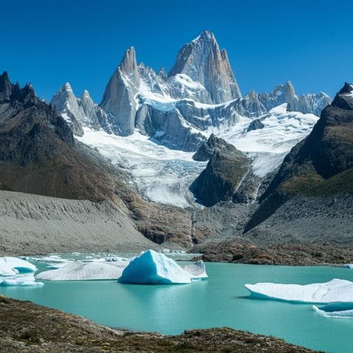
Rapid glacier retreat and downwasting throughout the European Alps in the early 21st century
C. Sommer, P. Malz, et al.
This groundbreaking study by Christian Sommer, Philipp Malz, Thorsten C. Seehaus, Stefan Lippl, Michael Zemp, and Matthias H. Braun reveals alarming trends in glacier dynamics in the European Alps between 2000 and 2014. The researchers found a staggering ice mass loss of 1.3 ± 0.2 Gt a⁻¹ and extensive glacier retreat, underscoring the urgent consequences of climate change on these vital ecosystems and their role in water resources and tourism.
~3 min • Beginner • English
Introduction
Glaciers in the European Alps have been retreating since the Little Ice Age (~1850), with accelerated shrinkage reported in recent decades and mass-change rates near −1 m w.e. a⁻¹ in the early 2000s. This continued reduction affects water supply, hydropower, civil security, and tourism, as mountain regions act as critical water towers with glacier melt contributing to late-summer runoff. Despite many studies, most focus on large catchments or limited in situ measurements, lacking representativeness, and a comprehensive, cross-border, methodologically consistent assessment over the entire Alps for the same observation interval has been missing. The study aims to quantify glacier-specific area and elevation changes and regional mass changes across all Alpine regions using consistent satellite-based methods for 2000–2012 and 2000–2014, to improve understanding of recent glacier dynamics and inform hydrological projections and socio-economic planning.
Literature Review
Prior work documented substantial global and Alpine glacier retreat since the Little Ice Age, with accelerated losses in recent decades. Reported mass-change rates in the Alps approached −1 m w.e. a⁻¹ in the early 21st century. Glacial melt significantly contributes to late-summer runoff in major Alpine river basins, but many prior Alpine studies rely on limited in situ networks and extrapolations, or focus on selected high-mountain subregions, potentially biasing Alpine-wide estimates. Geodetic estimates from Switzerland, Austria, France, and Italy show strongly negative mass balances, though values vary with method, period, and region. Recent syntheses reported average specific mass losses of ~−0.87 m w.e. a⁻¹ (2006–2016) for the Alps and Pyrenees and more negative values post-2010 associated with warmer summers. A gap remains for an Alpine-wide, temporally consistent, cross-border geodetic assessment harmonized in methods and time windows.
Methodology
Study area subdivision followed the International Standardized Mountain Subdivision of the Alps (ISMSA), computing geodetic mass-change rates for Western/Eastern Alps and ten glacierized subregions (excluding regions with <10 km² glacierized area). Data sources: (1) SRTM C-band DEM (February 2000) and TanDEM-X X-band SAR acquisitions providing two DEM mosaics covering the Alps (2011–2012 and 2013–2014); (2) Landsat optical imagery (185 scenes from 1999–2001, 2011, 2013–2015) for glacier area mapping contemporaneous with DEMs. Area mapping: Band ratios (red/SWIR) were thresholded to binary masks, vectorized to polygons, and constrained by RGI v6 divides and attributes. For glaciers with multiple summer scenes, outlines were automatically selected using criteria comparing extent to RGI stats and Landsat QA clear-pixel metrics; where equal quality existed, the smallest area was chosen. Incomplete coverages were mosaicked from multiple scenes and manually checked. Debris-covered ice was corrected using elevation change fields, high-resolution imagery, and Sentinel-1 coherence (2015) to distinguish debris-covered ice from bedrock. Area-weighted median acquisition dates were computed per region to derive area-change rates. Elevation change: TanDEM-X DEMs were processed via differential InSAR using SRTM as reference; interferograms were filtered/unwrapped, DEMs geocoded and coregistered (vertical and horizontal) to SRTM over stable, low-slope, non-vegetated areas. TanDEM-X mosaics retained per-pixel acquisition dates. Elevation change rates (Δh/Δt) were computed by differencing TanDEM-X and SRTM using acquisition dates; data voids were filled using a Δh/Δt versus altitude function aggregated in 100 m bins with a 1–99% quantile filter and removal of steep slopes (>50°). Geodetic mass change: Volume change integrated Δh/Δt over the spatial union of outlines at the period endpoints (Smax) and applied a correction for relative X- vs C-band radar penetration (Vpen), modeled as linearly increasing from 0 m at minimum glacier elevation (10th percentile) to 5 m at maximum glacier elevation per region. Mass changes used a fixed density 850 ± 60 kg m⁻³. Specific mass change divided volume change by temporal mean area (S3) per UNESCO recommendations. Uncertainty: Propagated errors from DEM differencing (including spatial autocorrelation via semivariograms; mean lag ~312 m), hypsometric gapfilling, glacier area mapping (scaled 3% area error adjusted by perimeter-to-area ratios per region; separate δS1 and δS2), density conversion (±60 kg m⁻³), and radar penetration bias (Vpen). Elevation change precision was estimated by slope-binned standard deviations on stable terrain, filtered outliers, and weighted by glacier slope distributions. Glacier-specific analyses: For glaciers with continuous glaciological records (WGMS), elevation changes were aggregated into relative elevation bins (10% of range or 50 m), filtered (1–99% quantiles), and hypsometric gaps filled with a 3rd-order polynomial; regional penetration corrections were applied, and uncertainties from regional Δh/Δt uncertainties were propagated. Present mass-change rates were compared to consensus ice thickness-derived volumes (Farinotti et al., 2019) to estimate remaining volumes in 2050 and 2100 under constant 2000–2014 relative rates (no dynamics or climate forcing changes).
Key Findings
• Alpine-wide retreat averaged ~39 ± 9 km² a⁻¹ (~1.8% a⁻¹) during 2000–2014. • Regionally averaged elevation changes were strongly negative across both Western and Eastern Alps, typically < −0.6 m a⁻¹; near-balanced conditions (~0 m a⁻¹) occurred only above ~3500 m a.s.l. in parts of the Graian, Pennine, and Bernese Alps, with no significantly positive values even at the highest elevations. • Low altitudes (< ~2000 m a.s.l.) experienced surface lowering up to ~5 m a⁻¹ in the Graian, Bernese, and Glarus Alps; local rates near glacier termini could be even more negative (e.g., < −8 m a⁻¹ at Grosser Aletsch terminus). • Specific mass change was similar between periods: −0.71 ± 0.14 m w.e. a⁻¹ (2000–2012) and −0.70 ± 0.13 m w.e. a⁻¹ (2000–2014). • Total Alpine mass loss for 2000–2014 was 1.3 ± 0.2 Gt a⁻¹ (~−1.2% a⁻¹ of 2000 volume). • Strongest downwasting occurred in the Glarus and Lepontine Alps (specific rates up to ~−1.03 m w.e. a⁻¹); Western and Southern Rhaetian Alps were slightly less negative (~−0.8 m w.e. a⁻¹). Within the Western Alps, Bernese was more negative (< −0.8 m w.e. a⁻¹) than Graian and Pennine (> −0.7 m w.e. a⁻¹), attributed to lower average elevations in Bernese. • Country-level specific mass losses were similar in the French, Swiss, and Austrian Alps (< −0.7 m w.e. a⁻¹), and slightly less negative in the Italian Alps (~ −0.6 m w.e. a⁻¹). • Neglecting area change (using constant RGI v6 area) would underestimate the total mass-change rate by ~14% for 2000–2014. • Under constant 2000–2014 relative loss rates (−1.0 to −2.3% a⁻¹ by region), many lower mountain ranges would become nearly ice-free by 2100; remaining Alpine glacier volume would be about one-third of that at 2000, with >10 km³ persisting primarily in Pennine and Bernese Alps. • Geodetic results are generally less negative than unadjusted glaciological records (mean difference ~0.18 m w.e. a⁻¹), with notable discrepancies at some very small glaciers; regional averages align well where measurement density is high.
Discussion
The study provides the first temporally consistent, cross-border geodetic assessment of Alpine glacier area, elevation, and mass changes for the early 21st century. The findings confirm widespread thinning and retreat across all major Alpine regions, with losses controlled by elevation distributions and glacier sizes: lower-elevation and large valley glaciers show the strongest downwasting, while only the highest zones approach balance in select high ranges. Regional contrasts (e.g., more negative in Bernese vs. Graian/Pennine) reflect altitudinal hypsometry, explaining variability in mass losses among subregions and countries. The results reconcile differences between geodetic and glaciological approaches, highlighting where in situ series may require calibration and where they are representative. The derived Alpine-wide mass loss of 1.3 ± 0.2 Gt a⁻¹ since 2000 and the sensitivity of estimates to evolving area emphasize the need to include area changes in mass-balance calculations. Projections under constant present rates suggest severe volume depletion by century’s end, particularly in lower mountain ranges, underscoring significant implications for late-summer runoff, hydropower, water resources, hazards, and tourism. The spatially comprehensive dataset enables improved calibration/validation of glacier evolution and hydrological models, thereby refining future runoff projections and risk assessments.
Conclusion
By integrating SRTM, TanDEM-X, and Landsat data with a consistent methodology, the study delivers an Alpine-wide, glacier-specific quantification of area, elevation, and mass changes for 2000–2014. Glaciers across the European Alps have experienced rapid retreat (~39 ± 9 km² a⁻¹) and significant mass loss (1.3 ± 0.2 Gt a⁻¹), with pronounced thinning at low elevations and only near-balance at the highest zones in select ranges. Regional differences are largely governed by altitude distributions and glacier geometries, with the strongest specific losses in the Glarus and Lepontine Alps. Assuming constant present rates, many lower ranges are projected to be nearly ice-free by 2100, with Alpine-wide volume reduced to roughly one-third of early 21st century levels. The dataset supports calibration of glaciological records and models, and informs water resource management, hydropower planning, hazard assessment, and tourism. Future work should incorporate dynamic glacier responses, climate projections, spatiotemporally varying density assumptions, and enhanced coverage of small and debris-covered glaciers to better constrain uncertainties and future trajectories.
Limitations
Extrapolations of present mass-change rates to future volumes do not include dynamic adjustments, climate forcing changes, or other feedbacks. Radar signal penetration corrections are approximated (linear altitude-dependent difference between X- and C-band), and actual penetration varies with surface conditions, seasons, and regions. DEM differencing uncertainties persist due to rugged topography, shadows, void interpolation, and limited DEM coverage in some high, complex areas. Area delineation errors, especially for small and debris-covered glaciers, and temporal mismatches in acquisition dates can introduce regional biases. A constant density (850 ± 60 kg m⁻³) was used instead of spatially/temporally varying densities, potentially affecting conversion from volume to mass. Although coverage spans glaciers representing ~93% of Alpine ice volume, incomplete coverage and interpolation may affect local-scale estimates.
Related Publications
Explore these studies to deepen your understanding of the subject.

